Perched at altitudes often exceeding 3,500 meters above sea level, the Puna of Catamarca is one of the most remote, pristine, and visually arresting regions of Argentina. This high-altitude plateau, part of the broader Andean Puna that stretches across Argentina, Chile, Bolivia, and Peru, is a land of extremes.
What makes Catamarca’s portion of the Puna unique is its blend of volcanic landscapes, immense salt flats, and surreal mineral-rich lagoons. Towering over the horizon are some of the world’s highest volcanoes, many of them dormant giants like Ojos del Salado—one of the highest volcanoes on Earth at 6,893 meters. The terrain shifts dramatically: one moment, you may be traversing an endless expanse of white at the Salar de Antofalla (one of the longest salt flats in the world), and the next, standing before the lava fields of Campo de Piedra Pómez, a labyrinth of wind-sculpted pumice stone.
Life in the Puna has an ancient rhythm. Villages like Antofagasta de la Sierra, El Peñón, and Antofalla preserve the traditions of the Kolla and Atacameña communities, whose livelihoods are rooted in herding llamas and cultivating quinoa in the thin, dry air. Archaeological remains and petroglyphs testify to the deep pre-Columbian history of the region, once part of Inca trade routes and earlier cultures that adapted ingeniously to this challenging environment.
The vastness and isolation foster a profound sense of awe, a place where nature still reigns absolute.
In this article we are going to talk about the Puna and its main attractions, in the surroundings of Antofagasta de la Sierra and Fiambalá, ideal starting point to get to know the Puna of Catamarca:
- Pumice Stone Field
- Antofagasta Volcanoes
- Salar de Antofalla
- Balcon del Pissis
- Ruta de los Seismiles
Table of Contents
What is the Puna?
The word Puna has a Quechua origin and means “High Altitude Region”.
The Puna ecoregion is located in the central mountain range of the Andes. It extends from Peru, through Bolivia, until the north of Chile and Argentina. The Argentine Puna, in the provinces of Salta, Jujuy and Catamarca, is located at an average altitude of around 3,500 meters.
Wildlife in the Puna de Atacama
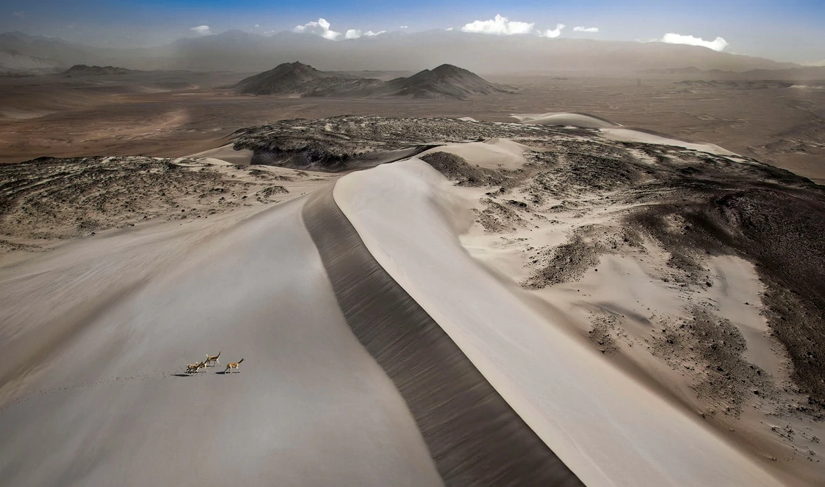
The most representative wildlife of the Puna includes vicuñas.
Among the birds, it is worth mentioning the presence of the flamingo, and the suri.
Climate in the Puna of Catamarca
The climate of the Puna has a wide thermal amplitude, which varies according to altitude.
Days can be warm under the intense Andean sun, but temperatures drop dramatically after sunset. Rainfall is scarce, the skies are almost always cobalt blue, and the clarity of the air reveals stunning night skies, making the Puna one of the best places in Argentina for stargazing.
It is always recommended to dress in layers, due to the large temperature variations.
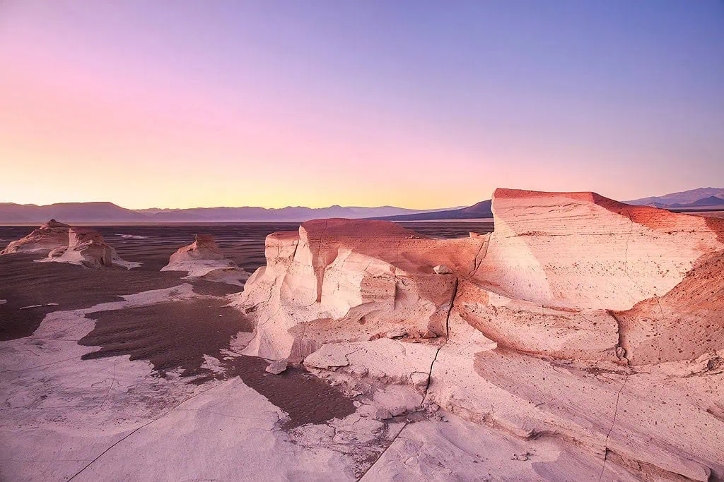
The Pumice Stone Field
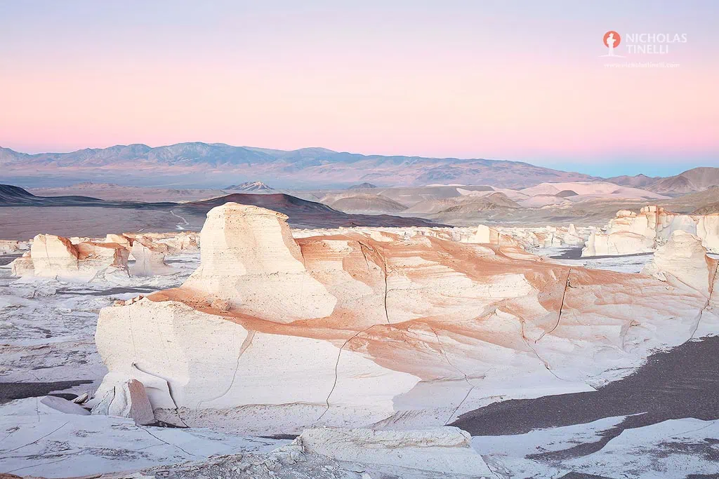
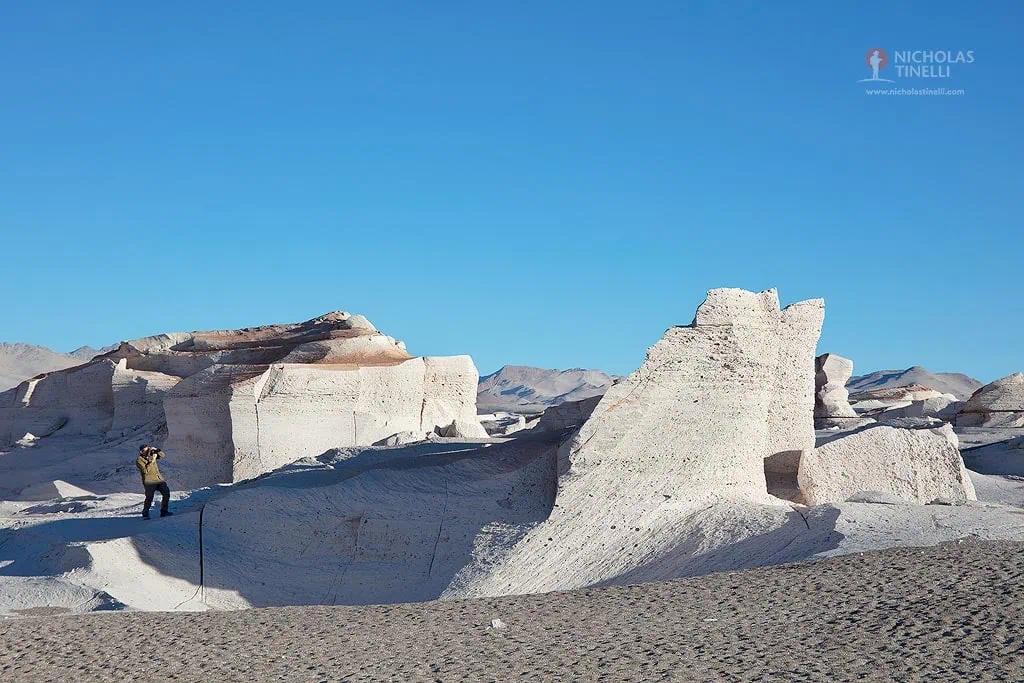
The Campo de Piedra Pómez (Pumice Stone Field) is one of Argentina’s most surreal and little-known natural wonders. Spanning more than 25 kilometers, this vast labyrinth of pale, wind-carved formations looks less like part of our planet and more like a fragment of a distant moon.
The field was born from a colossal volcanic explosion thousands of years ago. Superheated volcanic material, ejected from nearby eruptions, cooled rapidly in the thin, dry atmosphere, trapping air bubbles inside the rock and giving pumice its distinctive lightweight, porous texture. Over time, relentless winds, extreme temperatures, and the occasional Andean storm sculpted the rock into towering walls, sharp ridges, delicate spires, and fantastical shapes.
The contrast of colors is striking: the almost pure white and soft beige of the pumice meets the deep cobalt of the high-altitude sky, with the rusty reds and chocolate browns of surrounding volcanic cones completing the scene. In the early morning or late afternoon, low light accentuates the textures, casting long shadows that transform the landscape into an abstract piece of art.
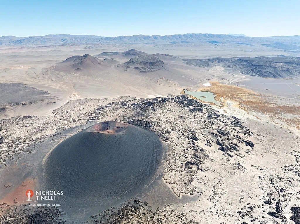
Antofagasta Volcanoes
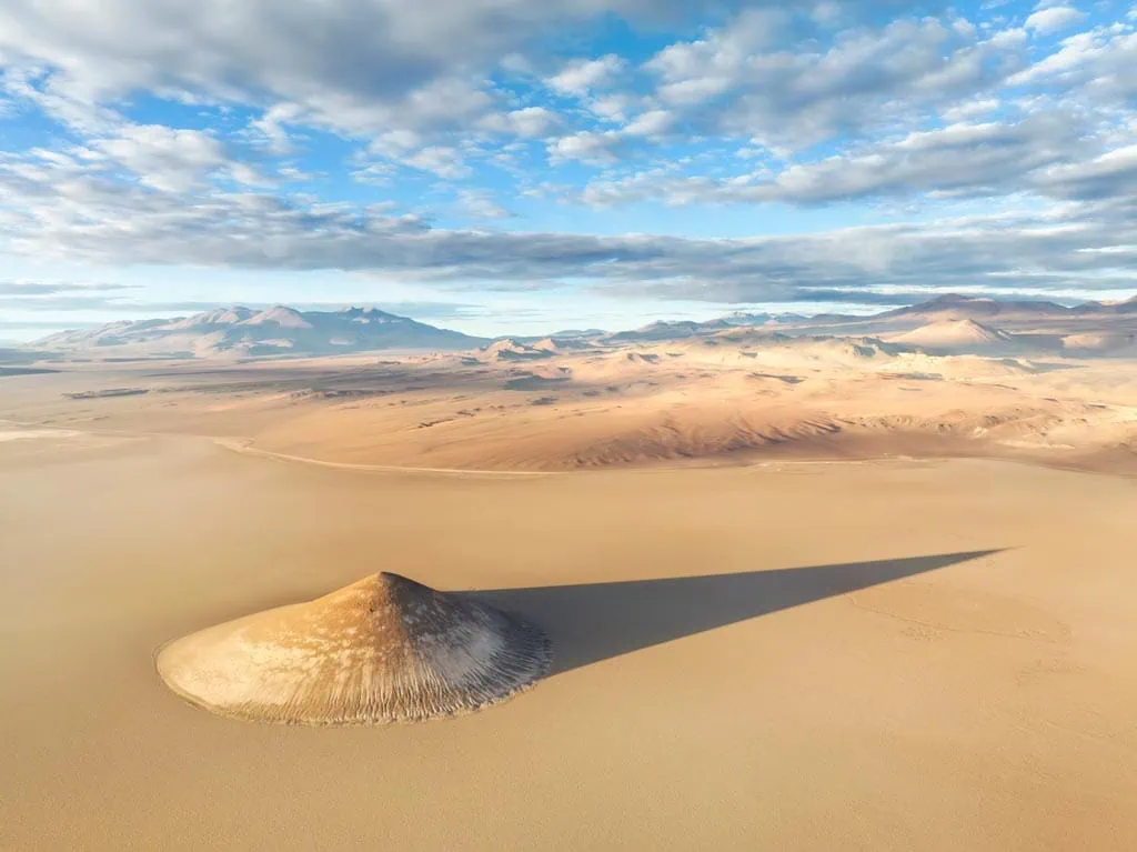
The small town of Antofagasta de la Sierra is surrounded by a silent army of volcanoes, ancient sentinels that have shaped the landscape for millions of years. This is one of the regions of Argentina with the highest concentration of volcanic cones, both inactive and extinct, whose size and colors defy all expectations.
The closer to the town are the Antofagasta, Alumbrera, Colorado, and Jote volcanoes.
The star of the area is the Galán Volcano, with its immense caldera (one of the largest in the world), and the Carachi Pampa Volcano, with its black basaltic cone rising beside a crimson-colored lagoon (visible from the Pumice Stone Field).
These volcanoes are more than geological curiosities; they are the architects of the surrounding landscapes. Their eruptions gave birth to the region’s striking features—vast pumice stone fields, rivers of frozen lava, and multicolored mineral deposits.
The harsh environment of the high Andes, with its thin air, intense sunlight, and freezing nights, has kept the area pristine. Few places on Earth feel as untouched. Yet, life persists—flamingos feed in mineral-rich waters, vicuñas graze on sparse tufts of grass, and the Kolla and Atacameña communities continue traditions rooted in centuries of adaptation to this volcanic land.
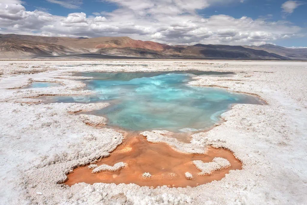
Salar de Antofalla
Stretching for more than 150 kilometers along the remote highlands of Catamarca, the Antofalla Salt Flat (Salar de Antofalla) is one of the longest in the world and a true hidden treasure of the Argentine Puna. At over 3,900 meters above sea level, this vast expanse of blinding white salt is framed by ochre mountains, and volcanic peaks.
The salar’s heart is a surreal mosaic of salt crusts, shallow lagoons, and mineral-rich surfaces that shimmer under the intense high-altitude sun.
On one side of the salt flat, you will find the small town of Antofalla, home to the Kolla Atacameña community. Its adobe houses, ancient irrigation channels, and traditions offer a glimpse into a way of life that has long been adapted to the extreme conditions of the Puna.
The Ojos de Campo formation (along with others) is an impressive sight in the salt flats: extinct geysers of salt water in different shades of blue, green, red, and orange. It can be accessed on 4×4 excursions with authorized guides.
Quebrada de Calalaste
At altitudes of over 4,000 meters, this remote Quebrada de Calalaste is surrounded by rugged peaks, volcanic slopes, and dry riverbeds shaped by millennia of wind and water.
Despite its arid appearance, Calalaste is a vital habitat for high-Andean fauna. It is particularly known for its large herds of vicuñas, which roam freely across the golden ichu grasslands. Andean foxes, and a variety of birds, complete the living tapestry of this untouched landscape.
The quebrada’s solitude is its greatest charm.
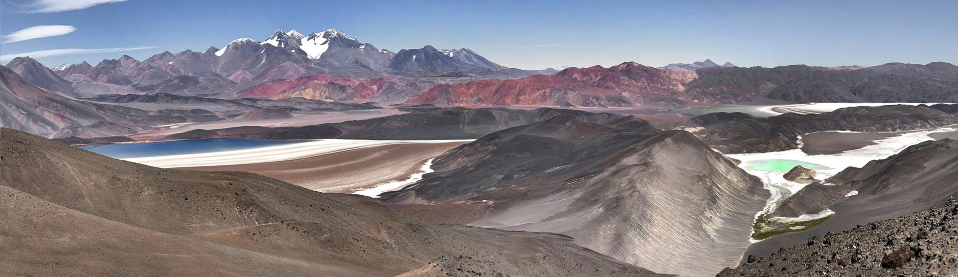
Balcon del Pissis
High in the Puna of Catamarca, along one of the most spectacular stretches of Route 60, lies the Balcón del Pissis — a natural viewpoint that frames one of the most imposing sights in the Andes: Mount Pissis. Rising to 6,793 meters, this dormant volcano is one of the highest mountain in the Western Hemisphere, a remote giant straddling the border between Argentina and Chile.
From the balcony, the panorama is nothing short of breathtaking. Mount Pissis dominates the horizon, its massive snow-covered slopes and glaciated peaks. On clear days, the crisp Andean air reveals details of the mountain’s ridges and valleys, offering a rare glimpse of its sheer scale and majesty.
Reaching the Pissis Balcony is itself an adventure, often requiring a 4×4 journey through rugged tracks at over 4,500 meters above sea level. But for those who make the trip, the reward is an encounter with one of the Andes’ most legendary peaks, seen from a vantage point that truly does it justice.
Standing there, with the wind sweeping across the plateau and the mountain rising in silent grandeur, it’s impossible not to feel the immensity — and the timelessness — of the Puna.
Ruta de los Seismiles
The Ruta de los Seismiles (Route of the Six-Thousanders) is one of the highest and most spectacular roads in the world. Winding through the Puna along Provincial Route 60, near the border with Chile, it takes its name from the extraordinary concentration of Andean peaks that rise above 6,000 meters — more than 20 in total — making this region a paradise for mountaineers, photographers, and lovers of extreme landscapes.
Here, volcanoes such as Ojos del Salado, Pissis, Bonete, and Tres Cruces dominate the horizon, their massive slopes capped with snow and ice even under the intense desert sun.
When to Travel?
The Best Time to Travel to the Puna of Catamarca is the fall (March to May) and spring (October to December).
How to Get to Catamarca?
The main cities to depart from, equipped with airports and regular flights from Buenos Aires, are Salta and San Fernando del Valle de Catamarca.
From there, it is recommended to travel with a 4×4 guide to explore the Puna de Catamarca. This is a very remote area, so it is best to venture out with the help of a local guide.
Discover the Puna de Atacama with Us!
4x4 Off-Road Adventure